Synopsis:
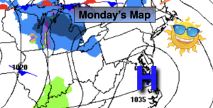
Monday will be chilly as Canadian high pressure settles along the East coast. Much of the day will be sun-filled. Clouds will roll in later in the afternoon.
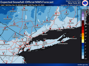
A warm front will approach tonight and Tuesday. A bit of snow is possible (starting between 3am-6am) mixing with and changing to rain at the coast before ending during the early afternoon. The potential for a light accumulations exists, mainly over Northwestern areas. Southern areas may not much in the way of any precipitation.
Christmas Eve will feature mostly sunny skies as high pressure slides in from the Great Lakes.
Christmas Day is looking dry at this time. Temperatures will be just above average the average high of the lower 40s.
A warm front will approach Thursday night and Friday. It maybe cold enough at the onset for a bit of frozen precipitation, especially North and West Friday morning. Mainly rain is expected for the afternoon hours.
Stay tuned.
Keep it here for a no nonsense, no hype forecast…
Monday:
Mostly sunny. Highs in the mid to upper 30s. Northwest to West winds at 5-10mph.
Tonight:
Cloudy. Snow/mix/rain developing. Lows in the mid 30s in the City, the upper 20s inland. West to Southwest winds at 5mph.
Tuesday:
AM Snow and or rain. Remaining mostly cloudy. Highs around 40º.
Christmas Eve:
Mostly sunny. Highs in the lower to mid 40s.
Christmas Day:
Sun and clouds. Highs in the mid 40s.
Friday:
AM mix mainly inland to rain. Rain at the coast. Highs in the mid to upper 40s.