Synopsis:
The last night of Autumn 2025 will be tranquil as high pressure moves off the Southeast coast.
Winter arrives at 10:03AM EST Sunday. The new season will be greeted by clouds giving way to sun as a cold front moves through. It’ll be windy with seasonal temperature. Average highs for the first day of Winter are in the lower 40s.
Monday will be colder as Canadian air filter in. Much of the day will be sun-filled. Clouds will roll in later in the afternoon.
A warm front will approach Monday night and Tuesday. A bit of snow is possible mixing with and changing to rain at the coast and to the South before ending midday. The potential for a light accumulations exists, mainly over Northwestern areas.
Christmas Eve will feature mostly sunny skies as high pressure slides in from the Great Lakes.
Mostly cloudy skies are expected Christmas Day. A few showers are possible with an approaching warm front. Temperatures will be just above average. Not looking like a white Christmas this year.
Stay tuned.
Keep it here for a no nonsense, no hype forecast…
Tonight:
Mostly cloudy. Lows in the mid 30s in the City, the 20s inland. South to Southwest winds at 5-10mph.
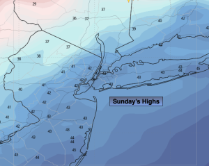
Sunday:
Clouds to sun. Windy. Highs in the lower 40s. West to Northwest winds increasing to 15-30mph with gusts to 35mph.
Monday:
Sun to clouds. Highs in the mid to upper 30s.
Tuesday:
AM Snow and or rain. Late day sun. Highs around 40º.
Christmas Eve:
Mostly sunny. Highs in the lower 40s.
Christmas Day:
Mostly cloudy. Few showers possible. Highs in the mid 40s.