Synopsis:
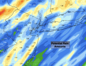
A potent cold front will move through our region later this morning. Rain will come down heavy at times. Many areas will receive an inch or more of rain.
Winds increase out of the South then switch to the West and Northwest later this morning and early afternoon. Gusts of 50mph are possible ahead of the front along the coastal plain. Once the front swings through during the winds will veer to the West, gusting up to 45mph throughout the day. Temperatures will start off very mild ahead of the front then drop into the 40s and 30s (inland) by late day.
The weekend will be bright and tranquil with high pressure dominating. Temperatures will be chilly on Saturday, but moderate some on Sunday.
Monday will be colder as Canadian air filter in.
A warm front will approach Tuesday with the potential of rain and snow showers. This does not look like a big deal.
At this time it doesn’t look optimistic for a white Christmas.
Stay tuned.
Keep it here for a no nonsense, no hype forecast…
Friday:
Morning rain then becoming mostly sunny. Windy. Falling temps. Highs in the mid 50s, falling into the 40s. Wind will gust 50mph in the morning out of the South along the coastal plain. Then switch to the West gusting to 45mph during the afternoon.
Tonight:
Mostly clear, windy and much colder. Lows in the 20s throughout. West winds at 15-30mph with gusts to 45mph. Winds will diminish some late.
Saturday:
Mostly sunny. Colder. Highs around 40º.
Sunday:
Mostly sunny. Highs in the mid 40s.
Monday:
Sunny. Colder. Highs in the mid 30s.
Tuesday:
Mostly cloudy with rain or snow showers. Highs around 40º.