Synopsis:
We’ll experience a mild push today as high pressure moves off the Southeast coast. Sun will give way to late clouds.
Rain is likely tonight and Friday morning with a cold front moving through. Temperatures on Friday will start off mild and drop into the 40s & 30s by mid to late afternoon. Winds will be strong out of the Southwest Thursday night then switch to the West and Northwest on Friday. Gusts to 50mph are possible.
The weekend will be bright and tranquil with high pressure dominating. Temperatures will be chilly on Saturday, but moderate some on Sunday.
Monday will be colder as Canadian air filter in.
Snow is not expected the next 7 days.
Stay tuned.
Keep it here for a no nonsense, no hype forecast…
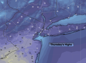
Thursday:
Sun to clouds. Milder. Highs in the lower 50s. Southeast winds at 5-10mph.
Tonight:
Cloudy with rain developing late. Rising temperatures. Lows in the 50s in the City, the 40s inland. Southeast to South winds increasing to 10-20mph gusting to 40mph late.
Friday:
Morning rain then becoming mostly sunny. Windy. Falling temps. Highs in the mid 50s, falling into the 40s. Wind gusts to 50mph.
Saturday:
Mostly sunny. Colder. Highs around 40º.
Sunday:
Partly sunny. Highs in the mid 40s.
Monday:
Mostly sunny. Colder. Highs in the mid 30s.