Synopsis:
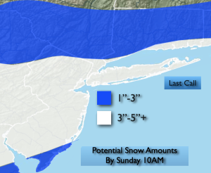
Snow will develop between 8pm-midnight and continue into early Sunday morning. Upper level energy and a weak wave of low pressure moving through the region is responsible for the white stuff. Accumulating snow is likely for much of the region. A general 3″-5″. Northern areas will receive lighter amounts while the urban corridor and areas to the South and East through Long Island will be the jackpot zone with some 6″ totals. The “last call” map is above.
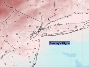
The 2nd big story will be the bitter cold on Sunday. Temperatures will actually fall during the day into the 20s. The wind will add to the misery with gusts up to 40mph. Wind chills will be in the teens during the afternoon. We’ll be in the freezer on Monday as the Arctic air remains over the Northeast. Tuesday will be bright but cold with high pressure overhead. We’ll come out of the freezer by midweek. In fact, by Thursday we’ll be flirting with 50º as high pressure moves off the Southeast coast.
Stay tuned.
Keep it here for a no nonsense, no hype forecast…
Tonight:
Snow developing. Cold. Lows in the 20s throughout. West to Northwest winds at 5-10mph.
Sunday:
Early morning snow, otherwise, partly sunny, windy and cold. Temperatures remaining in the 20s. North to Northwest winds at 15-30mph with gusts to 40mph.
Monday:
Sun to clouds, breezy and cold. Highs around 30º.
Tuesday:
Sunny. Highs in the lower to mid 30s.
Wednesday:
Sunny. Not as harsh. Highs in the lower 40s.
Thursday:
Sun to clouds. Milder. Scattered PM Showers. Highs around 50º.