Synopsis:
Any scattered showers of rain or snow will end this morning. The first weekend of December will be chilly. Skies will remain mostly cloudy. Readings will approach 40º in many areas. More sun is expected for Sunday as high pressure ridges in from the Great Plains.
Another blast of Arctic air will arrive Monday with readings once again hard pressed to get above freezing. Tuesday we’ll come out of the ice box, just barely! It’ll be a better feel Wednesday as a Southwest flow of somewhat milder air works in ahead of an approaching cold front.
Stay tuned.
Keep it here for a no nonsense, no hype forecast…
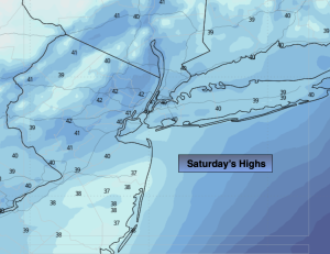
Saturday:
Slight chance of a light scattered showers AM mix, otherwise, mostly cloudy. Highs around 40º. West winds at 5-10mph.
Tonight:
Becoming mostly clear. Lows around 32º in the City, the 20s inland. West winds at 5mph.
Sunday:
Partly sunny. Highs around 40º.
Monday:
Partly sunny. Much colder. Highs around freezing.
Tuesday:
Sunny. Highs in the mid 30s.
Wednesday:
Partly sunny. Milder. Highs in the mid 40s.