Synopsis:
Today is the coldest day of the season so far. A Canadian airmass is paying a visit. Readings will be hard pressed to get to freezing in the City. Inland temperatures will remain below 32º. Low pressure off the Carolina coast will be responsible for cloudy skies to the South of the City. To the North of the City the sun will dominate.
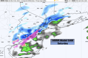
A trough of low pressure will pivot into our area from off the coast tonight into Saturday morning. There maybe enough moisture with it to cause scattered areas of snow showers, freezing drizzle and showers. The precipitation type will be temperature dependent. Where the precipitation is frozen a few slick spots are possible. This will not be a widespread or heavy event. Think scattered, with many areas North and west not seeing anything.
The first weekend of December will be chilly. Clouds will dominate Saturday. More sun is expected for Sunday as high pressure ridges in from the Great Plains.
Another blast of Arctic air will arrive Monday with readings once again hard pressed to get above freezing. Tuesday we’ll come out of the ice box, just barely!
Stay tuned.
Keep it here for a no nonsense, no hype forecast…
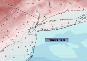
Friday:
Sun North. Clouds South. Cold. Highs in the lower 30s. East winds at 5mph.
Tonight:
Cloudy. Scattered areas of very light precipitation. Areas well inland should remain dry. Lows around 30º in the City, the 20s inland. East to North winds at 5mph.
Saturday:
Slight chance of a light scattered showers AM mix, otherwise, mostly cloudy. Highs around 40º.
Sunday:
Partly sunny. Highs around 40º.
Monday:
Partly sunny. Much colder. Highs around freezing.
Tuesday:
Sunny. Highs in the mid 30s.