Synopsis:
A cold front will approach the region today. A mix of sun and clouds is expected. A few flurries are possible with the front. Winds will be busy during the day with gusts increasing to 35mph during the afternoon hours. A cold blast will arrive Thursday night and Friday. Readings will be only near freezing under a mix of sun and clouds Friday. Low pressure will slide to our South Friday night. A few snow showers can’t be ruled out to the South of the City.
The first weekend of December will be chilly under partly sunny skies as high pressure ridges in from the Great Plains.
Another blast of Arctic air will arrive Monday with readings once again hard pressed to get above freezing.
Stay tuned.
Keep it here for a no nonsense, no hype forecast…
Thursday:
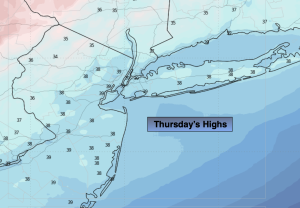
Partly sunny. Becoming windy. A few flurries possible. Highs around 40º. West to Northwest winds at 10-20mph with gusts to 35mph during the afternoon.
Tonight:
Mostly clear and very cold. Windy early. Lows around 20º in the City, the teens inland. Northwest to North winds at 15-30mph with higher gusts in the evening. Diminishing to 5-10mph late.
Friday:
Sun to clouds. Cold. Highs in the lower 30s.
Saturday:
Partly sunny. Highs around 40º.
Sunday:
Partly sunny. Highs around 40º.
Monday:
Partly sunny. Much colder. Highs around freezing.