Synopsis:
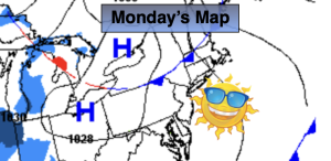
Monday will feature high pressure moving in. Skies will be sunny with below average temperatures.
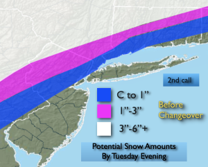
On Tuesday low pressure developing over the Southeast. This low will move up and off the our coastline while strengthening. At the onset it will be cold enough for some wet snow to develop along and North and West of the I-95 corridor during the mid morning hours. A quick slushy coating is possible in this area at most. It will turn to all rain. Cold high pressure is lacking to our North. The wind will come off the milder Atlantic waters during the day. Any snow or mix will go over to rain over the nearby suburbs. Inland a mix of snow and some rain will continue. In this region accumulation is likely, especially over the higher elevations. The first guess map is above. These are potential amounts and are not etched in stone. Several inches of snow is possible well inland. The storm will pull away Tuesday evening with precipitation coming to an end.
High pressure will build into the region on Wednesday and Thursday with sunny, chilly conditions.
A cold blast will arrive on Friday with readings only near freezing under mainly sunny skies.
Stay tuned.
Keep it here for a no nonsense, no hype forecast…
Monday:
Sunny, chilly and breezy. Highs in the lower 40s. Northwest winds at 10-15mph.
Tonight:
Mostly cloudy. Lows in the mid 30s in the City, the 20s inland. North to East winds at 5mph.
Tuesday:
Mix/rain at the coast to rain. Snow/mix inland. Highs in the 30s to around 40º.
Wednesday:
Sunny. Highs around 40º.
Thursday:
Partly sunny. Highs in the lower 40s.
Friday:
Mostly sunny. Cold. Highs in the lower 30s.