Synopsis:
High pressure over the Southeast and low pressure in Eastern Canada will continue to result in breezy conditions through the end of the week. Readings will be several degrees below the average high of the mid 50s under a mix of clouds and sun.
The weekend right now looks like a 50/50 split. Winds will relax by Saturday as another high moves in from the North. Skies will be partly sunny. Sunday will feature a cold front working through. Showers are likely for the early morning. The sun will return for much of the day. Readings will recover seasonal averages- the mid 50s.
Monday will see a return to cooler under partly sunny skies.
Stay tuned.
Keep it here for a no nonsense, no hype forecast…
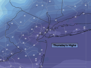
Thursday:
Partly sunny, breezy and cool. Highs in the lower 50s. West to Northwest winds at 10-20mph with gusts to 25mph.
Tonight:
Partly cloudy. Lows in the 30s throughout. West winds at 10-15mph.
Friday:
Mostly sunny. Highs around 50º.
Saturday:
Sun to afternoon clouds. Highs around 50º.
Sunday:
Showers likely in the morning. Becoming sunny and windy. Highs in the mid 50s.
Monday:
Partly sunny. Chilly. Highs in the upper 40s.