Synopsis:
Today will feature more clouds as low pressure begins to develop well to our South and West. Spotty showers are possible along Southern coastal areas. The low will move up the spine of the Appalachians on Thursday. The flow around this low will bring a slug of rain up from the South Thursday. This looks to be a quick hitter with some downpours and gusty winds. One to three inches of rain is possible with local street and highway flooding. Fallen leaves may leave drains clogged adding to ponding of water. Minor coastal flooding is possible at times of high tide.
Halloween will be dry, windy and cool. Saturday will feature a chilly breeze under a mix of sun and clouds. Sunday will be the more tranquil day of the weekend with a continuation of our chilly temperatures.
Stay tuned.
Keep it here for a no nonsense, no hype forecast..
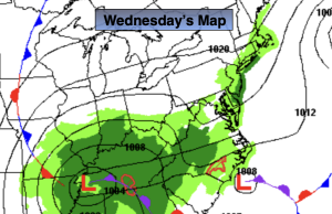
Wednesday:
Mostly cloudy. Spotty afternoon showers possible. Highs in the mid 50s. Northeast winds at 10-15mph.
Tonight:
Cloudy with showers developing. Lows in the 40s throughout. Northeast 8-15mph.
Thursday:
Rain likely. Windy. Highs near 60º.
Halloween:
Mostly cloudy. Windy. Highs in the mid to upper 50s.
Saturday:
Partly sunny. Breezy. Highs in the upper 50s.
Sunday:
Sunny. Highs in the mid 50s.