Synopsis:
Readings will be more seasonable today under a mix of sun and clouds as high pressure moves offshore. Autumn arrives at 2:19PM EDT.
The first full day of Fall on Tuesday will feel more like Summer. Readings flirt with 80º as a Southwest wind brings up the warmth. A late day storm can’t be ruled out.
Wednesday will feature a mix of sun and clouds. A few showers are possible as a moist flow develops off the ocean.
Thursday and Friday will be unsettled. A stationary front will be draped along the East coast. On and off showers are likely. Readings will be cooler.
Stay tuned.
Keep it here for a no nonsense, no hype forecast.
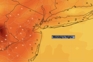
Monday:
Sun and clouds. Seasonable. Highs in the mid 70s. Southeast winds at 5-10mph.
Tonight:
Partly cloudy. Lows in the mid 60s in the City, near 60º inland. Southwest winds at 5mph.
Tuesday:
Partly sunny. Warm. Chance of a late day storm. Highs near 80º.
Wednesday:
Sun and clouds. Scattered showers. Highs in the mid 70s.
Thursday:
Cloudy. Showers likely. Cooler. Highs around 70º.
Friday
Mostly cloudy. Chance of morning showers. Highs in the lower to mid 70s.