Synopsis:
The last weekend of Summer will feel more like Fall as Canadian high pressure influences our weather. The sun will dominate. Readings will be a few degrees below the average high of the mid 70s.
Readings will be more seasonable on Monday under mostly sunny skies as high pressure moves offshore. Autumn arrives Monday at 2:19PM EDT.
The first full day of Fall on Tuesday will feel more like Summer. Readings flirt with 80º as a Southwest wind brings up the warmth. A late day storm can’t be ruled out.
Wednesday will feature a mix of sun and clouds. A few showers are possible as a moist flow develops off the ocean.
Stay tuned.
Keep it here for a no nonsense, no hype forecast.
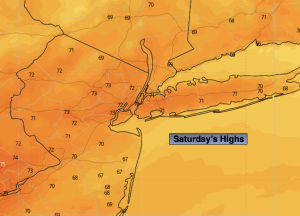
Saturday:
Sunny. Cooler. Highs in the lower 70s. East to Southeast winds at 8-12mph.
Tonight:
Clear. Cool. Lows in the upper 50s in the City, the 40s & 50s inland. East winds at 5mph.
Sunday:
Mostly sunny. Highs in the upper 60s to around 70º.
Monday:
Mostly sunny. Seasonable. Highs in the mid 70s.
Tuesday:
Partly sunny. Warm. Chance of a late day storm. Highs in the lower 80s.
Wednesday:
Sun and clouds. Scattered showers. Highs in the mid 70s.