Synopsis:
The heat will continue to be the main story through midweek. The sun will rule the sky today. Humidity will rise to uncomfortable levels by Wednesday. Many regions will experience a heat wave (3 consecutive days above 90º). Spotty storms are possible Wednesday and Thursday afternoon as a weak cool front approaches. This front will bring down the humidity for late week into the weekend. It’ll still be warm, but not as hot.
Tropical Storm Erin continues to move through the far Eastern Atlantic. Many days to watch this system as it is expected to become a powerful hurricane.
Stay tuned.
Keep it here for a no nonsense, no hype forecast…
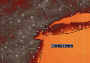
Tuesday:
Hazy, hot and humid. Highs in the lower 90s. Southwest winds at 5-10mph.
Tonight:
Clear, warm and muggy. Lows in the mid 70s in the City, the 60s inland. Light winds.
Wednesday:
Hazy, hot and humid. Chance of afternoon spotty storms. Highs in the lower 90s.
Thursday:
Partly sunny, very warm. Spotty storms. Highs in the upper 80s.
Friday:
Sunny, not as humid. Highs in the upper 80s.
Saturday:
Mostly sunny. Highs in the mid to upper 80s.