Synopsis:
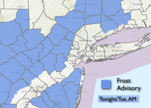
The coldest air of the season so far will make a visit to our area the next two days. Cold high pressure originating in central Canada will move to the Eastern states this week. A Frost Advisory has been posted for many areas outside of the City and urban corridor.
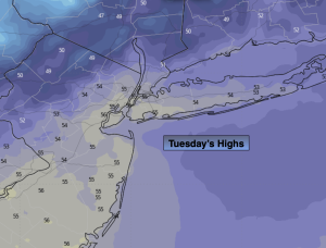
Tuesday and Wednesday will feature a gusty wind and nip in the air with readings around ten degrees below the average high of the mid and upper 60s.
Readings will recover to seasonable levels by Friday as the cold high modifies and becomes a mild weather maker by the weekend.
Stay tuned.
Keep it here for a no nonsense, no hype forecast.
Tonight:
Mostly clear, breezy and much colder then recent nights. Scattered frost inland. Lows in the lower 40s in the City, the 30s and lower 40s inland. Northwest winds at 10-20mph and diminishing.
Tuesday:
Partly sunny, windy and much cooler. Highs in the mid 50s. Northwest winds at 10-20mph with gusts to 30mph.
Wednesday:
Mostly sunny. Windy and chilly. Highs in the mid 50s.
Thursday:
Sunny. Cool. Highs around 60º.
Friday:
Sunny. Seasonable. Highs in the mid 60s.
Saturday:
Sunny. Mild. Highs in the lower 70s.