Synopsis:
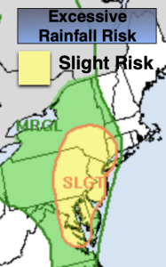
A slow moving area of low pressure and cool front will approach the region today. Humid air will be in place. Scattered showers and storms are possible just about anytime. There will be prolonged periods of dry times. Locally heavy rain is possible. A Flood Watch is up for NJ, Rockland and Westchester counties through tonight. Locally one to three inches of rain is possible. Flooding of streets, highways, streams and creeks are possible. If you encounter a flooded roadway, TURN AROUND, DON’T DROWN.
Any of the storms maybe strong to severe later today, especially over NJ. Keep an eye for threatening weather conditions.
On Monday the front will be slow to move off the coast. A mix of sun and clouds is expected. Scattered showers and storms are possible later in the day.
A cool pool of air will make a visit from Canada midweek. Tuesday and Wednesday temperatures will be in the 70s, well below the average high of the lower to mid 80s. A mix of sun and clouds is expected. The mercury will reach the 80º mark by Thursday.
Stay tuned.
Keep it here for a no nonsense, no hype forecast.
Sunday:
Mostly cloudy. Humid. Scattered showers and storms. Highs in the upper 70s. Southeast winds at 8-15mph.
Tonight:
Scattered showers and storms. Humid. Lows in the lower 70s the City, the 60s inland. Southeast winds at 5mph.
Monday:
Sun and clouds. Late afternoon showers and storms are possible. Highs in the lower 80s.
Tuesday:
Partly sunny. Cooler. Highs in the mid 70s.
Wednesday:
Partly sunny. Highs in the mid to upper 70s.
Thursday:
Partly sunny. Highs around 80º.