Synopsis:
More clouds than sun is expected for Sunday. We’ll get a break from the hot temperatures but humidity levels will still be high. Scattered storms are possible during the afternoon with a weak disturbance over the region.
Monday will be mainly sunny and hot. There should be a noticeable drop in humidity.
A weak stationary front will over the area Tuesday through Thursday. Tuesday’s readings will be near the average high of the mid 80s. On Wednesday and Thursday a somewhat cooler flow from the North may develop keeping our readings in the 70s! Showers and storms are possible each day.
JMW will continue to monitor Tropical Storm Debby. The storm will make landfall late tonight possibly as a hurricane over the big bend area of Florida. Does the storm stall out over the Southeast or ride up and off the coast late week? Some rain is possible over our region, but its way too early for any concrete forecasts.
Stay tuned.
Keep it here for a no nonsense, no hype forecast.
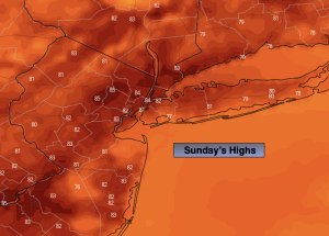
Sunday:
Clouds and sun, warm and humid. Scattered PM storms. Highs in the mid 80s. Southwest winds at 5-10mph.
Tonight:
A scattered evening storm, otherwise partly cloudy. Lows in the lower 70s in urban areas, 60s inland. West winds at 5mph.
Monday:
Mostly sunny and hot. Highs around 90º.
Tuesday:
Hazy, warm and humid. Spotty PM storm. Highs in the mid 80s.
Wednesday:
Clouds and sun. Cooler. Scattered showers. Highs in the mid 70s.
Thursday:
Clouds and sun. Scattered showers. Highs in the upper 70s.