Synopsis:
A tropical flow combined with a weakening stationary front over the region will result in areas of morning rain. Some of the rain will be heavy. The good news is the system will washout out and exit the area during the afternoon. The sun will make a visit. Temperatures will be seasonable. The average high temperature is in the mid 80s.
Sunday will be the better half of the weekend with mainly sunny skies. The Western Atlantic high will continue to influence our area. This setup will cause temperatures and humidity levels to once again become quite uncomfortable. The 90s will once again greet us. Intense heat is likely Tuesday and Wednesday. The heat index will approach 110º in some regions.
The thunderstorm threat will be Monday and Wednesday afternoon (scattered in nature).
Stay tuned.
Keep it here for a no nonsense, no hype forecast.
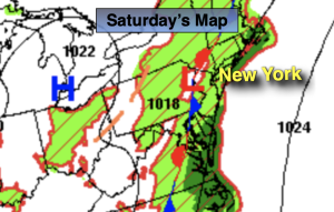
Saturday:
Areas of morning rain, otherwise becoming partly sunny. Highs in the mid 80s. Southwest to South wind at 5-10mph.
Tonight:
Partly cloudy and muggy. Lows in the lower to mid 70s in the City, the 60s inland. South to North winds at 5mph or less.
Sunday:
Hazy, hot and humid. Highs around 90º.
Monday:
Hazy, hot and humid. Chance of an afternoon storm. Highs in the lower 90s.
Tuesday:
Hazy, hot and humid. Highs in the mid to upper 90s. Heat index: 100º-110º.
Wednesday:
HHH. Spotty PM Storms. Highs in the mid to upper 90s. Heat index: 100º-110º.