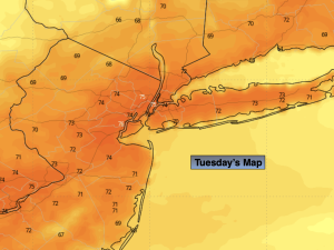
Synopsis:
We’ll go from cool to hot this week.
An upper level low with a with a comfortable airmass will keep temperatures below seasonable levels Tuesday (the upper 70s). Skies will be partly sunny. High pressure will begin to build over our area Wednesday. Temperatures will become seasonable and then go above average through late week. A Summer preview will greet the region Thursday and Friday as a Southwesterly flow dominates around a Western Atlantic high. Skies will remain mostly sunny with haze and humidity building on Friday. Showers and storms are possible Friday afternoon and evening with an approaching cool front.
By Saturday, strong high pressure will move into the region with abundant sunshine. It’ll be warm with much lower humidity. A top ten day for sure!
Stay tuned.
Keep it here for a no nonsense, no hype forecast.
Tuesday:
Partly sunny. Cooler. Highs in the lower to mid 70s. Light and variable winds.
Tonight:
Partly cloudy. Lows in the lower 60s in the City, the 50s inland. Light and variable winds.
Wednesday:
Sunny. Warmer. Highs around 80º.
Thursday:
Sunny. Warmer. Highs in the upper 80s.
Friday:
Hazy, hot and humid. Chance of afternoon and evening storms. Highs in the lower 90s.
Saturday:
Sunny. Much less humid. Highs in the mid 80s.