Synopsis:
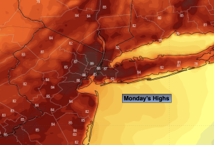
The week will start of warm under a mix of clouds and sun. Readings today will be almost ten degrees above the average high of the mid 70s. Weak high pressure along the Northeast coast will influence our weather through Tuesday. It’ll be more seasonable on Tuesday.
Wednesday will start off with some sun but clouds will win the battle as a warm front approaches from the South. Spotty showers are possible during the afternoon.
Low pressure and the front will move into and through the area on Thursday. Scattered showers and storms are possible just about any time. It’ll be humid.
Leftover showers are possible on Friday but some sun should shine as well as upper level energy moves into the Northeast.
Stay tuned.
Keep it here for a no nonsense, no hype forecast.
Monday:
Clouds and sun. Warm. Highs in the mid 80s. Northeast to East winds at 5mph.
Tonight:
Mostly clear. Lows in the mid to upper 60s in the City, the upper 50s & lower 60s inland. Southeast to East winds less than 5mph.
Tuesday:
Mostly sunny. Highs in the upper 70s.
Wednesday:
Sun to clouds. Spotty afternoon showers. Highs in the upper 70s.
Thursday:
Mostly cloudy. Humid. Scattered showers and storms. Highs around 80º.
Friday:
Clouds and sun. Spotty showers. Highs in the upper 70s.