Synopsis:
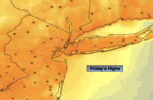
May will wrap up on a beautiful note with high pressure in control. Abundant sunshine and seasonable readings are expected for Friday. Average highs are in the mid 70s.
The first weekend of June will be a winner. High pressure will continue to dominate our region. Readings will pop into the 80s both days.
Sunday night and Monday morning feature a weak low moving through the region. Scattered showers are possible at this time. It should be a quick mover with the sun retuning later Monday morning.
We’ll be back to our fine June conditions on Tuesday. Plenty of sun and warm readings are in the forecast as high pressure re-establishes itself over the Northeast.
Stay tuned.
Keep it here for a no nonsense, no hype forecast.
Friday:
Sunny. Highs in the mid 70s. Northwest winds at 8-12mph.
Tonight:
Clear. Comfortable. Lows in the lower 60s in the City, the 40s & 50s inland. Northwest winds 5-10mph.
Saturday:
Sunny. Warmer. Highs in the lower 80s.
Sunday:
Sun to late clouds. Highs in the lower 80s.
Monday:
Morning showers to sun. Highs around 80º.
Tuesday:
Mostly sunny. Highs around 80º.