Synopsis:
A cool front approaching from the West will cause scattered showers and storms into this evening. Some of the rainfall will be locally heavy. Isolated severe storms are possible. We’ll dry out after midnight and skies will become partly cloudy.
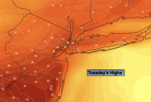
Heading back to work and school on Tuesday it will be sun-filled with warm readings. Highs will be five to seven degrees above the average high of the mid 70s.
Wednesday will feature a weak disturbance moving through. Any morning sun will give way to clouds and scattered afternoon showers.
Thursday through Saturday will be delightful with plenty of sun. High pressure will move into the region. Temperatures will be seasonable.
Stay tuned.
Keep it here for a no nonsense, no hype forecast.
Tonight:
Scattered showers and storms into the evening. Some of the rainfall will be locally heavy. Isolated severe storms are possible. Becoming partly cloudy overnight. Lows in the mid 60s in the City, around 60º inland. Southeast to Southwest winds 5mph.
Tuesday:
Mostly sunny. Warm and breezy. Highs in the lower to mid 80s. West winds at 10-20mph with gusts to 25mph.
Wednesday:
Sun to clouds. Chance of afternoon showers. Highs in the mid 70s.
Thursday:
Clouds to sun. Highs in the mid 70s.
Friday:
Sunny. Highs in the mid 70s.
Saturday:
Sunny. Highs in the upper 70s.