Synopsis:
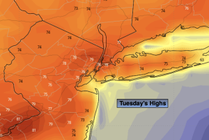
A winner is expected for Tuesday with readings ten degrees above the average high of the upper 60s.
A weak low will move through the region on Wednesday. More clouds than sun is expected. Scattered showers and isolated storms are possible mainly in the morning. The majority of the day will be dry. It will be warm.
On Thursday, high pressure off the Northeastern coast will result in a wind off the chilly Atlantic. This will cause a dramatic drop in temperatures. A front to our South will result in grey skies and an increasing chance of showers turning into a steadier rain later in the day.
A weak low will move through the region on Friday. It’ll be chilly with on and off showers.
By Saturday, enough drier air will work in from the West to allow for a mix of sun and clouds. Temperatures will be several degrees below average.
Stay tuned.
Keep it here for a no nonsense, no hype forecast.
Tuesday:
Mostly sunny. Warmer. Highs around 80º. Northeast to South winds at 5-10mph.
Tonight:
Partly cloudy. Lows around 60º in the City, the 50s inland. South winds less than 5mph.
Wednesday:
Mostly cloudy. Warm. Spotty showers and storms mainly in the morning. Highs around 80º.
Thursday:
Showers developing. Steadier rain late. Much cooler. Highs in the mid 60s.
Friday:
Scattered showers. Cool. Highs in the lower 60s.
Saturday:
Partly sunny. Highs in the mid 60s.