Synopsis:
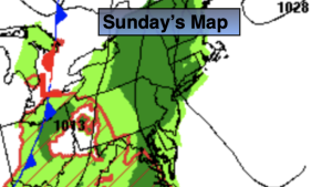
It’ll be a Sunday spoiler with on and off showers becoming steadier and heavier during the afternoon. Raw is the best way to describe the feel. Readings will remaining in the 50s throughout. The disturbance responsible for our dreary conditions will move through the region overnight with rain coming to an end.
Clouds will give way to sun on Monday. Readings will pop to almost twenty degrees higher than they were on Sunday. A rollercoaster ride in temperature continues.
A winner is expected for Tuesday with readings almost ten degrees above the average high of the upper 60s.
Another weak low will move through the region on Wednesday. More clouds than sun is expected. Scattered showers and isolated storms are possible. It will be warm.
On Thursday, high pressure off the Northeastern coast will result in a wind off the colder Atlantic. This combined with a weak disturbance to our South will result in on and off showers and much cooler readings.
Stay tuned.
Keep it here for a no nonsense, no hype forecast.
Sunday:
On and off showers. Steadier during the afternoon. Chilly. Highs in the mid and upper 50s. Southeast winds at 8-12mph.
Tonight:
Scattered showers. Lows in the 50s throughout. Southeast to South winds at 5mph.
Monday:
Clouds to sun. Milder. Isolated shower. Highs in the mid 70s.
Tuesday:
Partly sunny. Warmer. Highs around 80º.
Wednesday:
Mostly cloudy. Warm. Scattered showers and isolated storms. Highs around 80º.
Thursday:
Mostly cloudy. Much Cooler. Scattered showers. Highs in the 60s.