Synopsis:
It’ll be a nice close to the workweek with more seasonable readings and bright skies as high pressure dominates the Northeast.
Saturday will feature any sunshine giving way to clouds as high pressure loses its punch along the East coast. It’ll be cooler with a marine influence. A few showers are possible by evening mainly inland.
Grab the umbrella for Sunday. Showers are expected with a disturbance moving over the area from the West.
Skies will clear out for Monday with pleasant highs. Readings will be several degrees above average. A winner is expected for Tuesday with readings almost ten degrees above the average high of the upper 60s.
Stay tuned.
Keep it here for a no nonsense, no hype forecast.
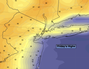
Friday:
Mostly sunny. Much cooler. Highs in the mid 60s, the upper 50s at the coast. East to Southeast winds at 8-12mph.
Tonight:
Partly cloudy. Lows in the upper 40s throughout. Southeast to East winds at 5mph.
Saturday:
More clouds than sun. Cooler. Chance of a shower over Western areas by evening. Highs in the lower 60s, 50s coast.
Sunday:
Showers. Chilly. Highs in the upper 50s.
Monday:
Clouds to sun. Milder. Highs in the mid 70s.
Tuesday:
Partly sunny. Warmer. Highs in the upper 70s.