Synopsis:
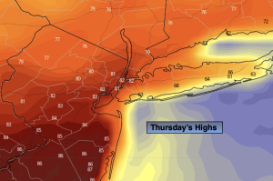
High pressure will build off the Southeast coast today. This will result in a warm push of air from the South and West. Readings will pop into the 80s away from the coast. The average high is in the upper 60s.
It’ll be a nice close to the workweek with more seasonable readings and bright skies.
Saturday will feature sunshine giving way to some clouds as high pressure loses its influence along the East coast. It’ll be cooler with a marine influence.
Grab the umbrella for Sunday. Showers are expected with a disturbance moving over the area from the West.
Skies will clear out for Monday with pleasant highs. Readings will be several degrees above average.
Stay tuned.
Keep it here for a no nonsense, no hype forecast.
Thursday:
Mostly sunny. Warmer. Highs in the lower to mid 80s. Cooler at the coast. West to Northwest winds at 8-12mph.
Tonight:
Clear. Lows in the 50s throughout. Northwest to Northeast winds at 5-10mph.
Friday:
Mostly sunny. More seasonable. Highs in the upper 60s.
Saturday:
Sun to clouds. Cooler. Highs in the lower to mid 60s.
Sunday:
Scattered showers. Cool. Highs in the upper 50s.
Monday:
Partly sunny. Warmer. Highs in the mid 70s.