Synopsis:
A front will move through this evening with an abrupt wind shift and period of heavy rain (in essence a squall line). Winds could gust over 45mph out of the West with the passage of the front. Readings will fall from the 60s to near freezing within 6-10 hours overnight.
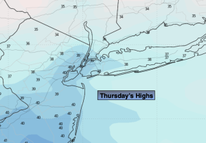
It’s back to reality on Thursday as a blast of cold air moves in on gusty Northwest winds.
It’ll be a fine Friday with high pressure overhead. Temperatures will be near the seasonable averages of the mid 40s. Weak low pressure along the Virginia coast on Saturday will move up and off our coast with a period of rain. Hopefully, the low will move out to sea on Sunday. At this time I’m keeping it dry under mostly cloudy skies. The clouds will win the battle on Monday as a marine influence continues to take hold on our region. Readings will be several degrees above the average high of the mid 40s.
Stay tuned.
Keep it here for a no nonsense, no hype forecast..
Tonight:
Period of rain and strong winds early this evening. Clearing skies. Temperatures will tumble into the lower 30s by daybreak . West winds at 15-30mph with gusts between 40-50mph.
Thursday:
Partly sunny, windy and colder. Highs around 40º. West to Northwest winds at 15-25mph with gusts to 30mph.
Friday:
Mostly sunny. Highs in the mid 40s.
Saturday:
On and off rain. Highs in the lower 50s.
Sunday:
Mostly cloudy. Highs in the mid 50s.
Monday:
Mostly cloudy. Highs in the mid 50s.