Synopsis:
The Spring feel will continue through midweek. Today will feature morning sun giving way to clouds. Scattered late afternoon showers are likely with an approaching warm front. On and off showers will continue tonight through Wednesday ahead of an approaching cold front. It won’t be a complete washout with peeks of sun possible. It’ll feel more like mid-April!
It’s back to reality on Thursday as a blast of cold air moves in on gusty Northwest winds.
It’ll be a fine Friday with high pressure overhead. Temperatures will be near the seasonable averages of the mid 40s. Weak low pressure along the Virginia coast on Saturday will potentially brush the region with a period of rain.
Stay tuned.
Keep it here for a no nonsense, no hype forecast..
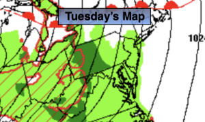
Tuesday:
Sun to clouds. Late afternoon showers likely. Mild. Highs in the upper 50s. Southeast winds at 5-10mph.
Tonight:
Periods of rain. Mild. Lows in the lower 50s in the City, near 50º inland. Southeast winds at 5-10mph.
Wednesday:
More cloudy. Scattered showers. Isolated storms. Warm. Highs in the lower 60s.
Thursday:
Partly sunny, breezy and colder. Highs around 40º.
Friday:
Sunny. Highs in the mid 40s.
Saturday:
Mostly cloudy. A period of rain possible. Highs in the lower 50s.