Synopsis:
A mild Monday will kick off the new week as a Southerly flow begins to take shape. This Spring feel will continue into the middle of the week. Tuesday will feature more clouds than sun with a spotty afternoon shower. Scattered showers are likely on Wednesday ahead of an approaching cold front. It won’t be a complete washout with peeks of sun possible. It’ll feel more like mid-April!
It’s back to reality on Thursday as a blast of cold air moves in.
It’ll be a fine Friday with high pressure overhead. Temperatures will be near the seasonable averages of the mid 40s.
Stay tuned.
Keep it here for a no nonsense, no hype forecast..
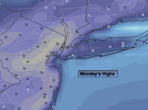
Monday:
Partly sunny. Mild. Highs in the lower to mid 50s. Southwest winds at 5-10mph.
Tonight:
Clear to partly cloudy. Lows in the mid 40 in the City, the 30s inland. Light Southeast wind.
Tuesday:
More clouds than sun. Spotty afternoon shower. Mild. Highs in the mid 50s.
Wednesday:
More cloudy. Scattered showers. Warm. Highs in the lower 60s.
Thursday:
Partly sunny, breezy and colder. Highs in the upper 30s.
Friday:
Sunny. Highs in the mid 40s.