Synopsis:
Clouds will increase today as a Southerly flow develops around a departing Atlantic high and as low pressure moves in from the West.
Showers will develop this evening and continue tonight and into Friday morning as weak low pressure makes its way into the region. There is no cold air with this system meaning no snow.
Colder air will filter in from Eastern Canada on Saturday as high pressure builds in from the West. Skies will at least be bright. Sunday will be sunny with readings moderating to near average.
A mild Monday will kick off the new week as a Southerly flow begins to take shape.
Stay tuned.
Keep it here for a no nonsense, no hype forecast..
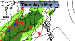
Thursday:
Sun to clouds. Few showers possible toward sunset. Highs in the mid 40s. South to Southeast winds at 5mph.
Tonight:
Areas of light rain. Lows around 40º in the City, the 30s inland. Southeast winds at 5mph.
Friday:
Morning light rain tapering off in the early afternoon. Some late day sun. Highs in the upper 40s.
Saturday:
Mostly sunny, breezy and colder. Highs in the mid 30s.
Sunday:
Sunny. Seasonable. Highs in the lower 40s.
Monday:
Partly sunny. Mild. Highs in the lower 50s.