Synopsis
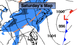
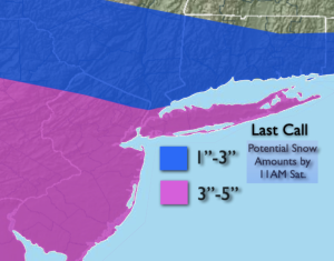
Weak low pressure will pass our region to the South tonight and Saturday morning. Snow is likely for much of the area. The snow should start within a couple hours either side of midnight and taper off soon after sunrise. It will be a quick hitter about 6 or so hours. The potential is there for 2″-4″ of snow in the NYC vicinity. Lighter amounts to the North. Areas to the South and West of the City will be in the jackpot zone with the potential of 3″-5″. Once the low moves out to sea sunshine is expected later Saturday morning and afternoon.
Sunday will be bright and chilly. Below seasonable average temperatures by five can be expected. The average high is in the lower 40s.
A sunny, seasonable Presidents’ Day is on the way- great skiing weather!
Tuesday and Wednesday will feature more of the same as high pressure influences our conditions.
Stay tuned.
Keep it here for a no nonsense, no hype forecast.
Tonight:
Thickening clouds with snow developing around midnight. Lows around freezing in the City, the 20s inland. Northwest to Northeast winds at 5mph.
Saturday:
Early morning snow. Becoming partly sunny. Highs in the upper 30s.
Sunday:
Partly sunny. Chilly. Highs in upper 30s.
Presidents’ Day:
Sunny. Seasonable. Highs in the lower 40s.
Tuesday:
Sunny. Highs in the lower 40s.
Wednesday:
Mostly sunny. Highs in the mid 40s.