Synopsis:
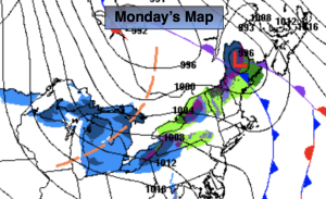
Rain will continue overnight as low pressure moves along the coast to the NYC area after midnight. Some of the rain maybe heavy for a time. The rain will end before sunrise.
It’ll be a seasonable start to the week (readings around 50º) with a mix of sun and clouds for Monday as the storm moves into New England. It’ll be breezy behind the departing low.
A Canadian blast will move in Tuesday. The coldest air of the season so far will pay us a visit. Readings Tuesday and Wednesday will most likely remain in the 30s for highs. A few flakes may fly on Tuesday with gusty winds. Gather up the firewood!
High pressure will move to off the Southeast coast later in the week. Readings will rebound to near average. A bright, tranquil day is anticipated for Thursday. Clouds will roll in on Friday ahead of a front approaching from the West. Showers are possible during the afternoon.
Stay tuned.
Keep it here for a no nonsense, no hype forecast.
Tonight:
Rain. Heavy for a time. The rain will end late. Lows in the mid 40s along the urban corridor, the 30s inland. Southeast to West winds at 8-12mph.
Monday:
Partly sunny. Breezy. Seasonable. Highs around 50º. West winds at 10-20mph.
Tuesday:
Partly sunny, windy and colder. Few flurries possible. Highs in the upper 30s.
Wednesday:
Partly sunny. Highs in the upper 30s.
Thursday:
Mostly sunny. Highs in the upper 40s.
Friday:
Mostly cloudy. Chance of afternoon showers. Highs around 50º.