Synopsis:
Trick or treaters will be dry this Halloween as cool air funnels down from the North. A mix of sun and clouds is expected with high pressure nosing in from the Northwest. There’ll be a nip in the air for sure.
A coastal storm will be develop well offshore tonight and Wednesday. It looks as though enough upper level energy and a surface trough from the low will cause areas of light rain overnight into Wednesday morning. The best concentration of this looks to be in the NYC vicinity and to the North and East. A bit of light wet snow may fly over the higher elevations and areas that are cold enough to support the flakes. Welcome to November! It’ll be cold with a gusty wind as the sun returns for many during the afternoon.
Chilly high pressure will move in for Thursday. Abundant sunshine with readings several degrees below the average high of the upper 50s is expected.
Friday will be more seasonable under plenty of sunshine as high pressure settles over the East coast.
Saturday will be a November gem with abundant sunshine and milder readings.
Stay tuned.
Keep it here for a no nonsense, no hype forecast.
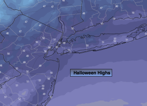
Halloween:
Partly sunny. Chilly. Highs in the lower 50s. Northeast winds at 5-10mph.
Tonight:
Areas of light rain. Some regions will remain dry. Lows around 40º along the urban corridor. Near freezing or in the 30s inland. Northeast winds at 5-10mph.
Wednesday:
Areas of light rain, some wet light snow may mix in for a time in colder areas. Some afternoon sun. Cold. Highs in the 40s throughout. Northeast winds at 5-10mph.
Thursday:
Sunny. Highs around 50º.
Friday:
Sunny. Highs in the upper 50s.
Saturday:
Sunny. Milder. Highs in the lower 60s.