Synopsis:
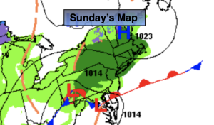
It’s a shocker walking outdoors this Sunday. Say goodbye to 80º of yesterday and hello to the 50s and times of showers today. This is all do to a much cooler flow coming out of New England with a frontal boundary to our South. The steadiest rainfall today will be from NYC and to the North. Father to the South the showers will be more widely scattered.
Scattered showers are expected overnight.
The front will get hung up over the region on Monday. A few showers are possible under a mostly cloudy sky.
On Halloween a significant cooldown is expected with dry conditions.
Wednesday’s coastal storm now looks to be farther offshore with the latest computer guidance. This will result in a drier output. A few showers are possible. Clouds will most likely give way to some sun during the afternoon. There will definitely be a nip in the air for this first day of November.
Chilly high pressure will move in for Thursday. Abundant sunshine and readings several degrees below the average high of the upper 50s is expected.
Stay tuned.
Keep it here for a no nonsense, no hype forecast.
Sunday:
Cloudy. Scattered showers. Steadier rain for a time to the North. Much cooler. Highs in the mid 50s. Northeast winds at 8-12mph.
Tonight:
Scattered showers. Lows around 50º along the urban corridor, the 40s inland. Northeast winds at 5-10mph.
Monday:
Mostly cloudy. Scattered showers. Highs in the 50s to around 60º. Warmer to the South. Temperatures falling during the afternoon.
Halloween:
Partly sunny. Chilly. Highs in the lower 50s.
Wednesday:
Clouds and sun. Scattered showers possible. Highs in the 40s to around 50º.
Thursday:
Sunny. Highs in the lower 50s.