Synopsis:
High pressure over the Southeast will dominate our weather through the first half of the weekend. The result will be unusually warm temperatures. It’ll feel more like June than later October through Saturday.
A cool front will move through the region Saturday evening. This will set the stage for much cooler temperatures for Sunday. It’ll be the tale of two season this weekend. Highs on Sunday will feel more like mid November with readings almost twenty five degrees cooler than Saturday. Showers are likely on Saturday.
The cool front will get hung up over the region on Monday. A few showers are possible. Slightly milder air may push up from the South leading to more seasonable readings. The average high is 60º.
On Halloween a signifiant cooldown is expected with dry conditions.
Stay tuned.
Keep it here for a no nonsense, no hype forecast.
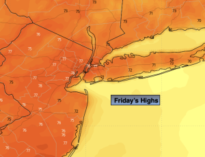
Friday:
Clouds and sun. Warm. Highs in the upper 70s. West to Southwest winds at 5-10mph.
Tonight:
Partly cloudy. Lows mid 60s along the urban corridor. This is warmer than the average high for the date. Readings will be in the 50s inland. Light West to Southwest wind.
Saturday:
Mostly sunny. Warm. Highs in the upper 70s.
Sunday:
Cloudy. Scattered showers. Much cooler. Highs in the mid 50s.
Monday:
Mostly cloudy. Seasonable. Scattered showers. Highs around 60º.
Halloween:
Partly sunny. Chilly. Highs in the lower 50s.