Synopsis:
A large dome of high pressure over the Eastern seaboard will dominate our weather through the first half of the weekend. The result will be soaring temperatures. It’ll feel more like early June than later October through Saturday.
A cool front will move through the region Sunday with scattered showers. Cooler temperatures are expected but readings will still be above the average high of around 60º. The front will meander along the Eastern seaboard on Monday. Conditions will be similar to that of Sunday.
Looking down the pike for Halloween a signifiant cooldown is expected with dry conditions.
Stay tuned.
Keep it here for a no nonsense, no hype forecast.
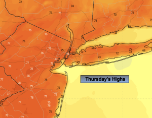
Thursday:
Mostly sunny. Warm. Highs in the mid to upper 70s. Light Southwest wind.
Tonight:
Partly cloudy. Lows in the lower to mid 60s along the urban corridor, the 40s and 50s inland. Light Southwest wind.
Friday:
Mostly sunny. Warm. Highs in the mid to upper 70s.
Saturday:
Mostly sunny. Warm. Highs in the upper 70s.
Sunday:
Mostly cloudy. Scattered showers. Cooler half of the weekend. Highs in the mid 60s.
Monday:
Mostly cloudy. Scattered showers. Highs in the mid 60s.