Synopsis:
Today and Thursday will be winners as high pressure begins to build into the region. A mix of sun and clouds is expected today and abundant sunshine is expected Thursday. Readings will be at or above the seasonable levels of the mid 60s.
A large trough in the upper atmosphere will result in a couple of unsettled days Friday and Saturday. Low pressure will develop off the coast Friday resulting in on and off rain. On Saturday, a second low will develop somewhere in the Northern Mid-Atlantic or Northeast. Most of the latest computer guidance have the storm North of the region on Saturday. If this outcome is correct, scattered showers will occur with the possibility of even seeing some sun. If the storm develops to our South, a steadier and heavier rain will occur. At this time JMW is leaning toward the first solution. This will be our 7th consecutive Saturday with rain. Oy vey!
The storm will become a powerhouse in New England on Sunday. Windy but dry conditions are expected. There will definitely be a nip in the air.
Stay tuned.
Keep it here for a no nonsense, no hype forecast.
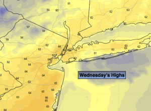
Wednesday:
Becoming mostly sunny. Highs in the mid 60s. Northeast to South winds at 5mph.
Tonight:
Mostly clear. Lows in the lower to mid 50s in urban areas, around 40º inland. Light South to Southwest wind.
Thursday:
Sunny. Milder. Highs in the upper 60s.
Friday:
Cloudy with periods of rain. Highs in the lower 60s.
Saturday:
Mostly cloudy with on and off showers. Highs in the lower 60s.
Sunday:
Mostly cloudy, windy and chilly. Highs in the upper 50s.