Synopsis:
Any morning sun will give way to thickening clouds today as the next system heads our way. A late day shower is possible as a trough of low pressure starts working in from the Atlantic . It’ll be a cool day with a wind off the ocean.
Unfortunately, more rain is in the forecast for Friday. Low pressure off the coast, along with a trough extending into our region will bring on and off rain to the area. Some of the rain maybe locally heavy.
Saturday will start off with clouds and the possibility of morning showers as once again we have a stubborn exiting low pressure. If we’re lucky we’ll get to see some late day sun.
October’s debut on Sunday looks spectacular with abundant sunshine and above average temperatures. The average highs are in the lower 70s. A string of beauties are expected well into next week!
Stay tuned.
Keep it here for a no nonsense, no hype forecast.
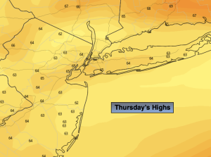
Thursday:
Becoming cloudy. Late day spotty shower possible. Highs in the lower to mid 60s. Northeast winds at 8-15mph.
Tonight:
Cloudy. Areas of light rain. Lows in the 50s throughout. Northeast winds at 8-15mph.
Friday:
On and off rain. Locally heavy. Highs around 60º.
Saturday:
Morning areas of rain, otherwise remaining mostly cloudy. A bit of late day sun is possible. Highs in the mid 60s.
Sunday:
Sunny. Warmer. Highs in the mid 70s.
Monday:
Sunny. Highs in the mid 70s.