Synopsis:
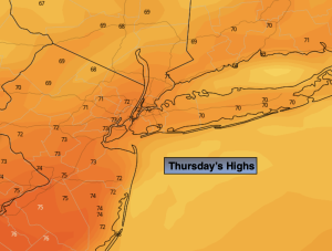
High pressure over the region continue to be responsible for our delightful last days of Summer. Abundant sunshine and comfortable temperatures will continue through Friday.
Low pressure over the Southeast will move North on Friday. By Saturday, the system will affect the region with some rain. The computer models are beginning to come into unison with the heaviest rain potential toward the coast and lighter amounts inland. Gusty winds are expected on Saturday as the pressure gradient tightens between the low to the South and high pressure over the Atlantic. It’s looking like a wet start to our new season of Fall. Autumn arrives at 2:50AM EDT Saturday. This low will be stubborn to exit resulting in the threat of on and off rain for Sunday. Not the best of weekends.
Stay tuned.
Keep it here for a no nonsense, no hype forecast.
Thursday:
Sunny. Highs in the lower to mid 70s. Northeast winds at 5mph.
Tonight:
Clear. Cool. Lows in the upper 50s in the City, the 40s inland. Light Northeast winds.
Friday:
Sun and afternoon high clouds. Highs in the lower 70s.
Saturday:
Rain likely. Windy, especially at the coast. Highs in the lower 60s.
Sunday:
On and off rain possible. Highs in the upper 60s.
Monday:
Morning showers possible, otherwise a mix of clouds and sun. Highs in the lower 70s.