Synopsis:
September’s debut will refreshingly cool as high pressure originating in Canada moves over the Northeast. Readings today will be a several degrees below the average high of the lower 80s. We’ll experience some great sleeping weather as well. Readings inland tonight will once again dip into the 40s in spots!
The entire Labor Day Weekend will be sunny with temperatures rising each day as high pressure becomes a warm weather maker. By the holiday many areas will be flirting with 90º. This Labor Day Weekend will be a memorable one for sure. Enjoy!
Back to work and school on Tuesday will feature more of the same as high pressure remains anchored over the East.
Stay tuned.
Keep it here for a no nonsense, no hype forecast.
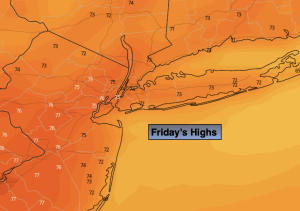
Friday:
Sunny. Highs in the mid 70s. Northeast to Southeast winds at 5-10mph.
Tonight:
Clear and cool. Lows in the lower 60s along the coast the 40s & 50s inland. Light Southwest winds.
Saturday:
Sunny. Highs around 80º.
Sunday:
Sunny. Warmer. Highs in the mid 80s.
Labor Day:
Sunny. Hot. Highs around 90º.
Tuesday:
Mostly sunny. Hot. Highs around 90º.