Synopsis:
Today will be day two of the heat wave as the Bermuda High remains parked off the Southeast coast. It’ll be quite hot and humid. The heat index will reach between 100º-106º. Please drink plenty of fluid, try to stay out of the heat of the day between 11am-4pm. Wear light weight, light colored clothing. Check on the elderly and pets often.
On Saturday a cool front will approach later in the day with a scattered storm. It’ll still be hot.
Relief will arrive on Sunday as a Canadian airmass moves in. Temperatures will be near the seasonable averages of the mid 80s.
Comfortable conditions will be with us as we turn the page to August. The sun will dominate.
Stay tuned.
Keep it here for a no nonsense, no hype forecast.
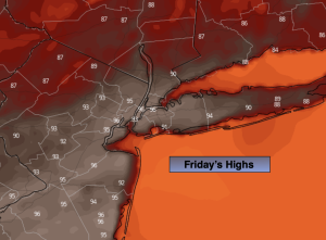
Friday:
Hazy, hot and humid. Highs in the mid 90s. Heat index: 100º-106º. West to Southwest winds at 8-15mph.
Tonight:
Mostly clear and very warm. Lows around 80º along the urban corridor, the upper 60s to 70s inland. West winds at 5mph or less.
Saturday:
Hazy, hot and humid. An isolated storm is possible. Highs in the lower 90s.
Sunday:
Mostly sunny. Cooler. Highs in the lower to mid 80s.
Monday:
Sunny. Highs in the lower to mid 80s.
Tuesday:
Sunny. Highs in the lower 80s.