Synopsis:
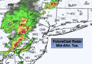
Mostly sunny skies and very warm temperatures are expected through midweek as high pressure dominates. A hiccup is likely later this afternoon and evening. The threat is there for scattered showers and storms later in the afternoon and evening as a weak disturbance moves through. A few of the storms maybe severe along with torrential rain. Eye to the sky for threatening weather after 3pm.
It’ll become hot and humid Wednesday through Saturday. Typical July conditions for sure as a Bermuda high sets up shop. It looks to be rain & storm-free through the period.
Enjoy and hydrate.
Stay tuned.
Keep it here for a no nonsense, no hype forecast.
Tuesday:
Mostly sunny. Scattered late afternoon and evening showers and storms. Highs in the mid to upper 80s. Southwest to South winds at 5-10mph.
Tonight:
Partly cloudy. Lows in the lower 70s in the City, the 60s inland. Southwest winds at 5mph or less.
Wednesday:
Hazy, very warm and humid. Highs near 90º.
Thursday:
Hazy, hot and humid. Highs in the lower to mid 90s.
Friday:
Hazy, hot and humid. Highs in the mid to upper 90s.
Saturday:
Hazy, hot and humid. Highs in the mid 90s.