Synopsis:
Mostly sunny skies and very warm temperatures are expected through midweek this week as high pressure continues to dominate. An isolated shower or storm is possible today and Tuesday (just had to mention it as most will be dry). It’ll become hot and humid Wednesday through Friday, typical July conditions for sure as a Bermuda high sets up shop. It looks to be rain & storm-free through the period.
Yep, a simple forecast, but, hey there is really nothing to elaborate on here. Enjoy and hydrate.
Stay tuned.
Keep it here for a no nonsense, no hype forecast.
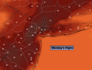
Monday:
Sun and clouds. An isolated shower or storm this afternoon. Highs in the mid to upper 80s. Cooler along the immediate coast. South winds 5-10mph.
Tonight:
Partly cloudy. Lows in the lower 70s in the City, the 60s inland. South winds at 5mph or less.
Tuesday:
Mostly sunny. An isolated afternoon shower or storm. Highs in the upper 80s.
Wednesday:
Hazy, hot and humid. Highs in then lower 90s.
Thursday:
Hazy, hot and humid. Highs in the lower to mid 90s.
Friday:
Hazy, hot and humid. Highs in the mid to upper 90s.