Synopsis:
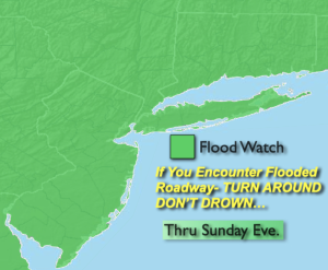
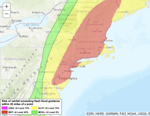
The weather pattern through Sunday is conducive for areas of torrential rain and thunderstorms. A Flood Watch and a moderate risk for excessive rain is in the forecast. Weak low pressure, very humid air and a disturbance in the atmosphere will result in the potential for up to a few to several inches of rain through this evening. Many areas are saturated from previous rainfall so it won’t take much for areas to flood. If you encounter a flooded roadway- Turn around don’t drown. You never know how deep the water is. Any scattered areas of rain or storms will end later this evening.
On Monday we’ll dry out. Bright, hot conditions are anticipated as weak high pressure develops over the region. Readings will be about five degrees above the average high of 85º.
Typical July conditions will continue Tuesday through Thursday under a mix of sun and clouds. A late day storm threat is possible on Tuesday.
Stay tuned.
Keep it here for a no nonsense, no hype forecast.
Sunday:
Mainly cloudy and humid. Scattered showers and storms. Some of the rainfall will be torrential. Highs in the lower to mid 80s. Southeast winds at 5-10mph.
Tonight:
Any areas of rain or storms will come to an end this evening. Becoming partly cloudy. Lows in the lower 70s in the City the upper 60s inland. South winds at 5mph.
Monday:
Mostly sunny. Highs around 90º.
Tuesday:
Partly sunny. Scattered showers and storms later in the day. Highs in the upper 80s.
Wednesday:
Mostly sunny. Warm. Highs in the upper 80s.
Thursday:
Mostly sunny. Highs in the mid to upper 80s.