Synopsis:
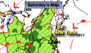
The beginning of the 4th of July weekend on Saturday looks like a winner. A mix of sun and clouds is expected. Readings will be near the average high of 84º. A warm front will approach the region tonight and Sunday. This feature will spark scattered showers and storms Saturday night into early Sunday morning. Sunday will not be a washout with only a few showers expected during the afternoon. It will most likely be the cloudiest day of the 4 day holiday weekend. There will be a noticeable increase in humidity.
A low pressure disturbance will cause scattered showers and storms Sunday night and then again Monday night. Most of Monday should feature hazy sun and much warmer readings.
The 4th of July forecast on Tuesday will make most smile. The disturbance should move out to sea leaving the area with a bright sky and hot, humid conditions. Many areas will take a run at 90º.
Hazy, hot and humid conditions will continue into Midweek.
Stay tuned.
Keep it here for a no nonsense, no hype forecast.
Saturday:
Sun and clouds. Highs in the lower to mid 80s. Cooler at the coast. Southeast winds at 5-10mph.
Tonight:
Mostly cloudy. Scattered showers and storms. Lows around 70º in the City, the 60s inland. Light Southeast winds.
Sunday:
Mostly cloudy. Scattered showers possible during the afternoon. Humid. Highs around 80º.
Monday:
Hazy, warm and humid. Highs in the upper 80s.
4th of July:
Hazy, hot and humid. Highs around 90º.
Wednesday:
Hazy, hot and humid. Highs around 90º.