Synopsis:
Smokey skies once again will be with us today. The winds will blow out of the Northwest transporting the smoke from the Canadian wildfires into our area.
Despite the smokey skies, it’ll be mostly sunny today and Friday. Warm temperatures are anticipated.
The beginning of the 4th of July weekend on Saturday will feature more clouds than sun. Scattered showers and storms are possible in the afternoon as a warm front approaches. The threat of showers and storms will continue for through Tuesday, July 4th as a weak disturbance remains over the region. It’ll be hazy and humid. It will not be a washout. Readings will be around the seasonable averages of the lower to mid 80s.
Stay tuned.
Keep it here for a no nonsense, no hype forecast.
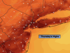
Thursday:
Mostly sunny. Smokey skies. Warm. Highs in the lower to mid 80s. Northwest to Southwest winds at 5-10mph.
Tonight:
Partly cloudy. Lows in the mid to upper 60s in the City, the upper 50s inland. Light Southwest winds.
Friday:
Mostly sunny. Highs in the mid 80s.
Saturday:
Sun and clouds. Scattered PM showers and storms. Highs around 80º.
Sunday:
More clouds than sun. Scattered PM showers and storms. Humid. Highs in the lower 80s.
Monday:
Sun and clouds. Scattered PM showers and storms. Humid. Highs in the lower to mid 80s.