Synopsis:
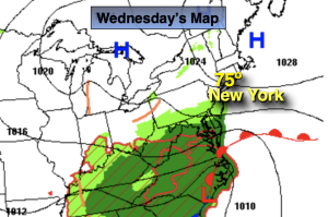
High pressure will continue to build over the Northeast through today. This will keep our area dry. There will be clouds from time to time from a Southern low trying to nudge North. Temperatures will be below the seasonable average of the lower 80s.
Summer arrives today at 10:58AM EDT. The longest amount of daylight of the year occurs today. This is also when the sun’s direct are the farthest North. The rays reach the Tropic of Cancer- 23.5º N latitude.
Moisture from a weak low over the Southern Appalachians will move North tonight and Thursday. Showers or even a period of rain is expected Thursday. The threat of showers (and an afternoon thunderstorm) will stick around Friday but it won’t be steady or widespread.
The high will shift off the coast on the weekend. This will result in a Southerly flow of humid air. A mix of sun and clouds is expected with a chance of a few showers or storms both days. It will not be a washout.
Stay tuned.
Keep it here for a no nonsense, no hype forecast.
Wednesday:
Sun and clouds. Breezy. Highs in the mid 70s. East 10-20mph with gusts to 25mph.
Tonight:
Cloudy with scattered showers late.. Lows around 60º in the City, the upper 50s inland. East to Northeast winds at 8-12mph.
Thursday:
Cloudy with on and off showers. Cool and breezy. Highs in the 60s to around 70º.
Friday:
Sun and clouds. Scattered showers and isolated storms. Highs in the upper 70s.
Saturday:
Sun and clouds. Humid. Spotty showers and storms. Highs in the lower 80s.
Sunday:
Sun and clouds. Humid. Spotty showers and storms. Highs in the mid 80s.