Synopsis:
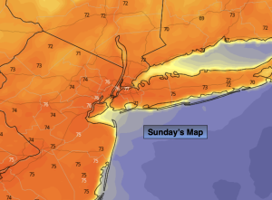
High pressure will continue to dominate our area through the weekend. This will allow for moderating temperatures and plenty of sunshine through midday Sunday. Clouds will roll in during the afternoon. Readings will be several degrees above the average high of 69º.
A weak disturbance moving rapidly through tonight will cause scattered showers.
It’ll be a Magnificent Monday as a ridge of high pressure prevails. Highs will be several degrees above average with wall to wall sunshine .
On Tuesday, a weak frontal boundary may cause a spotty shower, otherwise a mix of sun and clouds is expected with seasonable readings.
Wednesday looks bright and pleasant as high pressure reorganizes along the Eastern Seaboard. A warming trend will begin on Thursday as the sun rules the sky.
Stay tuned.
Keep it here for a no nonsense, no hype forecast.
Sunday:
Mostly sunny. Clouds will win the battle through the afternoon. Warmer. Highs in the mid 70s. West to Southwest winds at 5-10mph.
Tonight:
Mostly cloudy. Scattered showers. Lows in the upper 50s in the City, the lower 50s inland. Southwest to Northwest winds at 5-10mph.
Monday:
Mostly sunny. Warm. Highs in the mid 70s.
Tuesday:
Clouds, some sun. Spot shower possible. Seasonable. Highs around 70º.
Wednesday:
Bright and pleasant. Highs in the upper 60s.
Thursday:
Sunny, Warmer. Highs in the mid 70s.