Synopsis:
The weekend will feature a complete turnaround from last weeks weather. High pressure will begin to build over the Northeast. This will allow for moderating temperatures and abundant sunshine for a change. Readings will be seasonable for early May on Saturday. Sunday will be a gem!
A weak disturbance moving rapidly through Sunday night will cause scattered showers.
It’ll be a Magnificent Monday as a ridge of high pressure prevails. Highs will be several degrees above average with wall to wall sunshine .
On Tuesday, a weak frontal boundary may cause a spotty shower, otherwise a mix of sun and clouds is expected with seasonable readings.
Wednesday looks bright and seasonable as high pressure reorganizes along the Eastern Seaboard.
Stay tuned.
Keep it here for a no nonsense, no hype forecast.
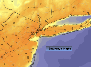
Saturday:
Mostly sunny. Milder. Highs in the in the lower 70s. Northwest winds at 5-10mph.
Tonight:
Clear. Lows in the mid 50s in the City, the 40s inland. West to Northwest winds at 5mph or less.
Sunday:
Mostly sunny. Warmer. Highs in the mid 70s.
Monday:
Mostly sunny. Warm. Highs in the mid 70s.
Tuesday:
Clouds, some sun. Spotty showers. Seasonable. Highs around 70º.
Wednesday:
Bright and seasonable. Highs around 70º.