Synopsis:
The pesky upper level low that has plagued the region will FINALLY begin to loosen it’s grip on the area today. This will allow for a bit more sun and not as cool readings. An isolated shower can’t be ruled out. Temperatures will be around ten degrees below the average high of 70º.
The weekend will feature a complete turnaround. High pressure will begin to build over the Northeast. This will allow for moderating temperatures and abundant sunshine for a change. Readings will be seasonable for early May on Saturday. By Sunday, most will welcome the 70s!
A gem is in the forecasts for Monday. Highs will be several degrees above average with wall to wall sunshine .
By Tuesday, a weak frontal boundary may cause a spotty shower during the morning. A mix of sun and clouds is expected with seasonable readings.
Stay tuned.
Keep it here for a no nonsense, no hype forecast.
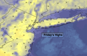
Friday:
Sun and clouds. Isolated shower. Highs around 60º. Northeast winds 5-10mph.
Tonight:
Spotty evening showers, otherwise partly cloudy. Lows in the upper 40s to around 50º in the City, the lower 40s inland. South to West winds less than 5mph.
Saturday:
Mostly sunny. Milder. Highs in the upper 60s.
Sunday:
Mostly sunny. Warmer. Highs in the mid 70s.
Monday:
Mostly sunny. Warm. Highs in the mid 70s.
Tuesday:
Partly sunny. Spotty morning showers. Seasonable. Highs around 70º.